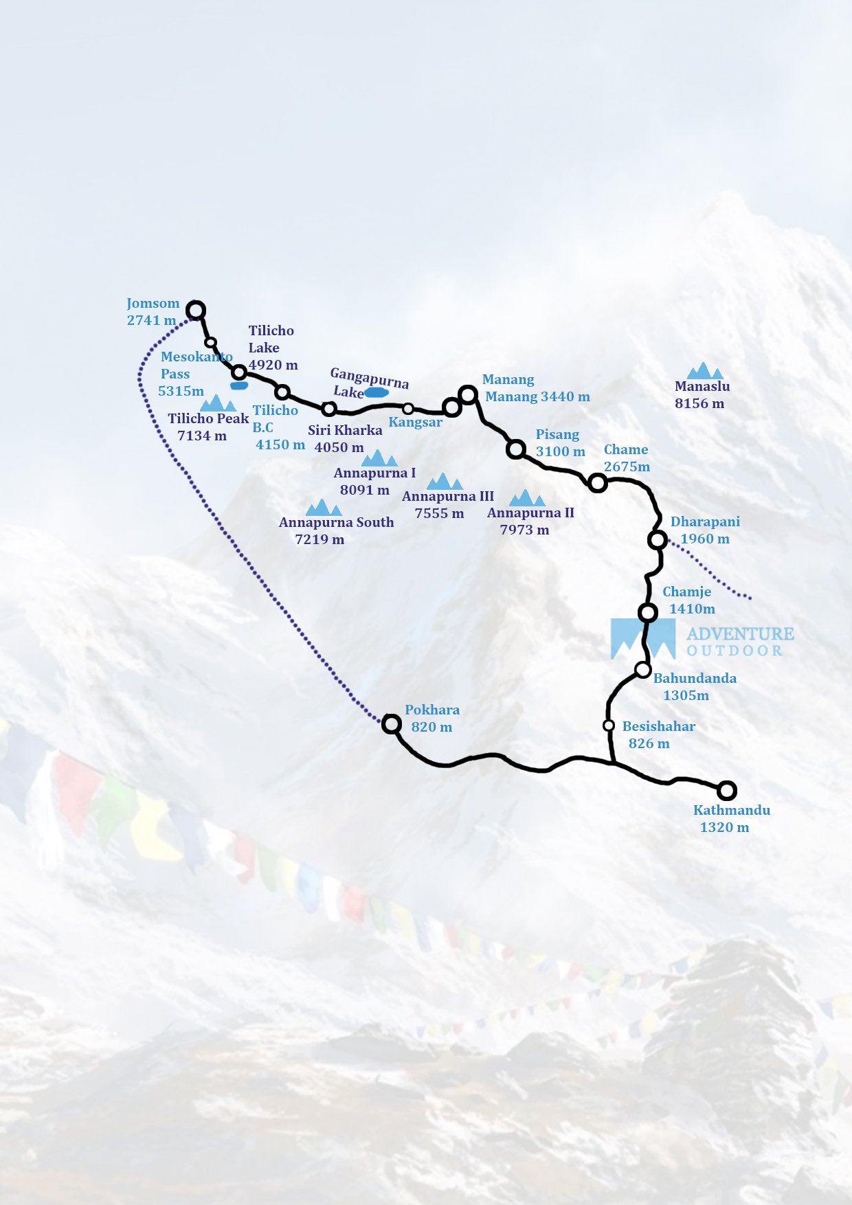
The starting point of the Tilicho lake trek is same as of Annapurna circuit i.e. Besisahar. Tilicho Lake is in the highest place of world at an elevation of 4949 meters. This lake lies in the Annapurna Range of the Himalayas in Manang region of Nepal. At that point the trek goes through the Khangsar and crosses by means of Thorong la pass or go to Jomsom by means of another pass Mesokanto La. Khangsar is an old style Tibetan town located at an elevation of 3700 meters. At that point it takes 6 to 8 hours to reach the Tilicho Base camp lodge. The hotel exhibit there is costlier than typical. In the year 2000; Russian jumping group led one of the most astounding ever scuba makes a plunge in Tilicho Lake. This likewise demonstrates this lake conveys probability for extraordinary compared to other goals for scuba jumping. Amid the trek; you can appreciate the situation of shocking rock developments, Tibetan towns, and high elevation brushing settlement, tight gulches, profound woods and glorious snow-clad pinnacles. This trekking also occurs in one of the most rural part of Nepal, so the facility of lodges and hotels may not be found everywhere in the route. Camping trek may be one of the best options for trekking in this region but nowadays lodges are available over there.
- Destination: Annapurna – Tilicho Lake (4949m)
- Group Size: min 1
- Max. Altitude: 4949m
- Grade: Strenuous
- Season: March to Mid-June, September – November
- Accommodation: Tea House./lodge
- Transportation: Tourist Bus, Private Car/Van
- Entry: Besisahar
- Exit: Pokhara
Our representative will pick you up at the airport. Get a feel for the streets the first day, absorb the sights and sounds, or rest at the hotel. We discuss the journey in the evening.
Kathmandu, the capital city, boasts an intense mix of cultures and religions unique to Nepal. Turn the Buddhist prayer wheels at Swoyambhu- the monkey temple and meet the steady gaze of the Buddha’s eyes at the famous Boudhanath stupa. Experience the valley’s olden days at the Kathmandu Durbar Square- which has remained authentic even as modernization has crept in all around it. See Kathmandu, with our trained guide. (or skip this and drive to Besisahar)
You drive along the Kathmandu-Pokhara highway to Dumre and afterward follow the thin and cleared road by the Marsyangdi River to Besisahar (823m.). Besisahar is the region central headquarter of Lamjung district. From here, you can see some of mountain crests, characteristic views encompassing the valley and the day by day exercises of nearby individuals.
The initial segment of the trail passes exhaustive level along the bank of the Marshyangdi waterway. You can appreciate the landscapes and the neighbourhood culture of Gurung people group. After lunch, the trail goes steeply upwards to Bahundanda which takes around 2 hours. Now, you can see the territory encompassed by eye-getting situations with snow-topped mountains.
A lofty trail drops for early thirty minutes and afterward finishes level way rice patios, before intersection a stream at the base of a little cascade. It at that point climbs again and crosses the slope high over the stream before achieving the town of Lali gaon. Ahead, the Marsyangdi valley frames a lofty V-shape and you take after the winding mountain way down through Syange (1100m.) where there is an excellent cascade above it and along the waterway for some separation. The trail at that point climbs steeply, and the way is cut into the sheer precipice confront some 200-300m over the riverbed. In the end you plunge to the stone town of Jagat (1330m.) arranged on a rack which extends into the sharp Marsyangdi valley.
The initial segment of the trail plummets to the waterway and after intersection a suspension bridge, you start a move to Sattale (1550m.) on a way so steep that it appears to be one slip would send you tearing down into the valley. You proceed with an undulating way over the stream and at one point where tributary streams in from the contrary bank, the fundamental waterway winds up secured with immense stones that conceal the water. Climbing the crisscross way to the highest point of the slope, you see the level, plain of Tal (1700m.) preceding us. Even though it is encased by precipices, the level territory looks consoling after the frightening mountain ways simply went on. You dive to a lush riverbank which prompts Tal with its inns and tea houses. Past Tal, the valley limits, and the way turns out to be high and twisting, and in a few zones from the stone itself. Past the little town of Karte (1900m.), there is more bluff strolling before the way drops again to the stream. You cross a suspension extension and climb the short separation to the stone khani denoting the passage to Dharapani (1960m.), and our camp for the night.
As the Marsyangdi swings to one side, and as Annapurna II ends up obvious ahead, you land at Bagarchhap, a Bhote town with supplication banners rippling in the breeze around Buddhist religious community. Proceeding to move through timberlands of pine and oak, you go through Danaque (2210m.). There is a little wooden extension which takes you to take after soak climb way up to Timang. It lies at the base of Lamajung Himal. The trail experiences level until the point when you achieve Chame where there are government workplaces, shops, and inns. Chame is the managerial central station for the Manang region.
With Lamjung Himal (6893m) shining toward the beginning of the day sun, you set off for Pisang. You proceed through a fir and pine woods, moving to a high, rough territory as the contrary bank turns into a blocked precipice. Starting here the valley turns out to be to a great degree soak sided as you take after the way to Bhratang (2950m.). A short move from the town conveys you to a stone strewn territory where you cross a wooden scaffold and take after a high, twisting way, before intersection back to the correct bank once more. You presently stroll through a pine woods and as the timberland closes, the valley changes from a V-shape to a delicate U-shape, opening a brilliant vista before us. You can see the east pinnacle of Annapurna II and Pisang Peak (6091m.) toward the north-east. Proceeding with, you go to a long mani divider by a scaffold and the lower town of Pisang.
Past Pisang, the trail climbs a lofty edge which bears great perspectives of the Manang valley and Tilicho crest (7145m.). Sliding past Manang's airstrip at Hongde (3320m.), you go to a level zone from where the north-east face of Annapurna III transcends you. From the wide fields of the Sabje Khola Valley, Annapurna IV (7525m.) additionally winds up noticeable. Just past this point you cross the impressively decreased stream of the Marsyangdi Khola by means of a wooden extension to the small town of Mungji. Vast chortens and mani dividers proliferate and the tall pinnacles of the Himalaya spread out before us - Annapurna II, Annapurna III, Annapurna IV, Gangapurna (7455m.) and, to the back, Tilicho Peak (7145m.). After a short soak climb you achieve Manang. You camp here for the night, during the shuddering petition banners, which enhance the houses.
You can either go out for a stroll, for example, crossing the stream to see the gigantic ice fall descending from the Annapurna's or moving high over the town for a full display of the Annapurna extend and the Manang Valley. There is likewise a Himalayan Rescue Association [HRA] help post in the town which makes an intriguing and instructive visit. Besides, you can visit Gangapurna Glacier Lake to make your rest day an important one.
The way is continuous plunge and you traverse Jharsing Khola (stream). You trek through dry land however you can see bushes on the two sides. The all-encompassing perspectives of Annapurna run totally hypnotize you. Khangsar is a Gurung town. There you locate a little religious community, chorten, mani dividers and petition banners.
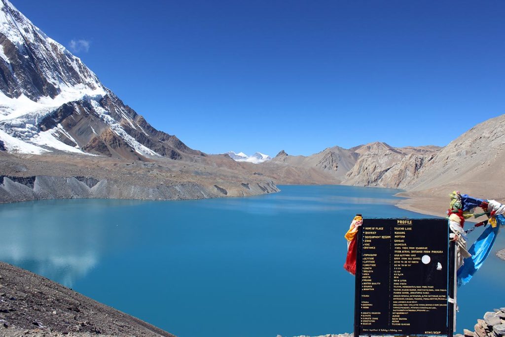
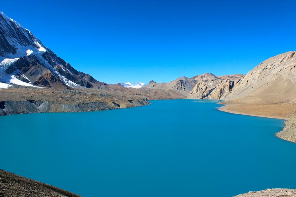
The way is secured by little gems and bushes can be seen on the two sides. Tilicho Lake is located at the statures. From here you can appreciate the closer and all-encompassing perspectives of Tilicho Mountain and numerous others.
The trail is very restricted, and you trek over cold way. The all-encompassing perspectives of Annapurna, Tilicho, Dhaulagiri alongside more than ten mountains totally hypnotize you.
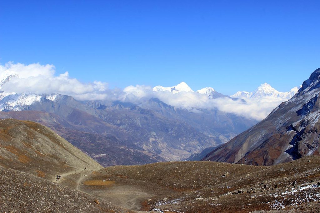
From Mesokanto Pass, the trail goes soak down to Jomsom. This day you trek through pine woodland. Before you reach Jomsom, you cross Thimi influenced by Buddhist culture.
Stroll around lake side and street of Pokhara city. Enjoy night at Pokhara.
Back to Kathmandu either via road drive or plane. Stay and calm at hotel and prepare for departure. Enjoy farewell dinner at the evening
Transfer to TIA airport before 2 hours to board.
Service Includes:
- Airport pick-up and drop-off services by private A/C car or Van
- Trekking guide/s
- Porter/s (1 porter carries 20 kilograms of luggage)
- All meals three times a day (breakfast, lunch and dinner) during the trek
- Accommodation in tea houses (lodges) during the trek
- Sleeping bags, down jackets, duffel bags and trekking sticks etc.
- Entry Permit for Annapurna conservation Area
- Trekkers' Information Management system (TIMS) card
- All land transportation wherever applicable
- 1-night hotel accommodation in Pokhara with breakfast
- Insurance and equipment's for the trekking staffs
- First aid kit
- Rescue assistance
- Farewell dinner
- All tax, VAT and company service charge
Service Not included:
- Personal nature expenses
- Drinks, beverages, hot shower, etc.
- Travel insurance (Should any emergency arise during your trek, we will provide prompt and professional rescue and medical services. For this, it would be better to have your own travel insurance that can cover helicopter evacuation and medical treatment cost in case required.)
- Tips
- Lunch and dinner in Pokhara
- Meals and hotel accommodation in Kathmandu
Frequently asked Questions
Annapurna Base Camp is a Grade B or a moderately difficult trekking route. So any fit person can do this trek, even if you do not have any previous experience. You should be aware of what to expect and mentally prepare for it. Then, as long as you will to, you can.
On average, you walk about 4 to 6 hours per day. One or two days can be as less as 3hrs and one or two days can be as long as 7hrs.
The highest altitude reached is 4190m. This is the elevation of Annapurna Base Camp. ABC is the highest we will climb in this trek.
Yes, you can charge batteries en route. Charger should be brought. There are hot shower facilities as well. You may have to pay certain amount for both ($1-$2). Negotiate. Also, hot water facility could be free at lower elevation.
No. There are no ATMs on this trek route. You will have to draw enough cash in Pokhara or Kathmandu. There are a number of ATMs in these cities. Everything is paid in Nepali rupees. So money should be exchanged before the start of the trek.
Yes. Internet can be accessed in most places. Sometimes, there might be some technical problems. Internet in Nepal is not as fast as you are used to and at times you can just lose connection.
Not really. It depends on you. If you want, ABC trekking can be done independently. You could hire a guide and a porter by yourself instead of going through an agency or not hire a guide at all. Although, not having a guide can be a little problematic during off season. It really depends on you. Is it your first time in Nepal? How confident are you of being able to find your way around? How pressed on time are you? If you go through an agency, it will be costlier but everything will be planned. You will only have to come, trek and return.
For Annapurna region, pay for guides range from $20 to $30 per day and porters take $15 to $25 per day.